Tuesday, October 22, 2013

Wyoming Gold, Diamonds, and Rattlesnakes


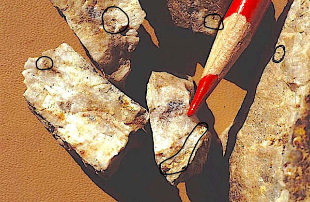
Quartz vein samples from Penn mines dumps containing visible gold recovered in 1981 (photo by
Dan Hausel). All photos in this blog (except Google Earth images), were taken by the author. 
Feel free to use, but please give proper credit.
(Revised 2/17/2022)
In 1981, Wyoming experienced its first significant gold rush in the 20th century, following a release by the Wyoming Geological Survey of a report on gold assays of rock collected at Bradley Peak in the Seminoe Mountains (some vein samples ran as high as 2.87 opt Au, and one altered banded iron formation sample assayed 1.14 opt Au). Companies, prospectors, consulting geologists all wanted to investigate this area, but the rush was short lived.

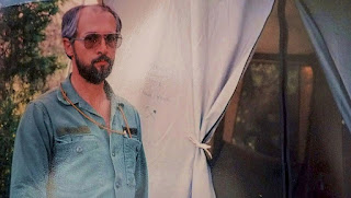
Years ago, at the entryway to the Bradley
Peak Hilton - a home away from home
After the announcement, all available motel rooms in Rawlins were booked solid by exploration geologists over the next two weeks. Not easy to do, since few like to spend time in Rawlins - its ugly, hot, dry and Wyoming constructed the State Prison near Rawlins. We may think of it as being not such a pleasant place, but rattlesnakes love it. And not so long ago, they added the Rochelle Ranch golf course, where deer and antelope play 18 holes along I-80. Almost as fancy as the Snake Hole 9-hole golf course and country club at Apache Junction in Arizona, with its dirt and gravel browns (aka greens). But, Rawlins took this another step - they actually have greens in between cactus, anthills, 18-wheelers, sagebrush and antelope. I don't play golf, but when I see classy courses like these, I spend time searching for used golf clubs at local garage sales.

After finding gold at Bradley Peak in the Seminoes, a few years later I met Dr. Terry Klein with the USGS. Over the next few years, our paths periodically intersected. Terry completed a PhD dissertation on the Seminoe Mountains and was the first to recognize komatiite meta-volcanics associated with this greenstone belt fragment, as well as a broad zone of propylitic alteration surrounding an area where I found some gold. This altered zone needed to be drilled and still remains mostly untouched. 

This discovery of significant gold in the Seminoe Mountains was the first of a few gold rushes initiated by geologists with the Wyoming Geological Survey at the University of Wyoming. But this particular gold rush to the Seminoe Mountains was short-lived - not because of the lack of gold, but because of a lack of access. After receiving a copy of the report, one Wyoming company quickly flew the Seminoe Mountains dropping claim posts out of a helicopter blanketing the entire area in a short time. I was later told by company geologists that many posts hit the ground and bounced down the steep sides of  Bradley Peak, while a few were caught in the tree top branches creating a whole, new, type of hazard for anyone walking through the trees during one of Wyoming's common and famous wind events. These are so common in Wyoming that Wyoming actually has wind festivals.

Normally, a sample like this would get one excited. It is
massive cuprite (red) with some malachite (green) and
tenorite (black). These are copper-oxides and -carbonate
But I think I got the entire Sunday Morning ore body
in this one specimen (photo by Dan Hausel).
After the gold discovery (or rediscovery), I initiated a field project in the Seminoes to search for gold - this was the early 1990s, after I had finished mapping at the South Pass greenstone belt. 

The Seminoes were a quiet place with no one around for miles. Basically, your nearest neighbor resides in Sinclair, 30 miles to the south. Personally, I loved working in the middle of no where. It grows on you to the point you periodically wonder if Ted Kaczynski was really all that crazy. I mean, the part about him living in the Montana mountains in a tiny, abandoned, one-room shack with no running water, sounds inviting; however, most people who do so either take up drinking, go crazy, or take up membership in the DNC. 

So, here I was, living at the top of Bradley Peak and breaking rocks for breakfast, lunch and dinner. But a few odd things happened to me when I was up there. One event repeated itself periodically at night, and I never figured out what was going on. It also happened again when I was mapping at South Pass and in the Lewiston area, a few years earlier. 

In the evening, I would climb into my sleeping bag with a gun and flashlight nearby. All of a sudden, I was startled awake by something running around my tent - very fast! I sat up and listened. It stopped. As I sat for a few more minutes, it started again - right next to my tent. What the heck? So, I slowly got out of my bag, turned on the flashlight and looked for a large rabbit, badger, fox, coyote, deer, zombie, or troll - I saw nothing. I stepped out of the tent searching for the critter - never saw it. This would happen periodically late at night. Based on the sound, I guess the mass of the critter was probably about that of a bobcat or mountain lion, but that was just a guess - I never saw the critter, nor could I find any tracks, nor can I think of what could run that fast around a tent in the dark.

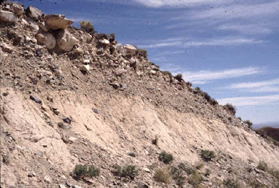
Recent conglomerate settling on top of false bedrock, Seminoe
Mountains paleoplacer gold (photo by Dan Hausel)
I ran into the land owner of the private property in parts of the Seminoe Mountains from the Miller Estate company. Frank was a congenial cowboy who gave me access to their road to the top of Bradly Peak, he was an outstanding person. Back in those days, people in Wyoming (with few exceptions) were friendly and helpful people. Sort of like the American Indian (I assume it's still ok to use the word 'Indian' unless you Woke up on the wrong side of politics) who rescued me from a quagmire along the north flank of Copper Mountain, and the prospector who rescued me from another quagmire at Lewiston in South Pass, and the hunters who... (well you get the idea, I used to get 4-wheel drives into places they were not suppose to be). 

Another day, I met two of the nicest people anyone could imagine standing on my doorstep at the Bradley Peak Hilton: two rancher/prospectors of the highest quality - Charlie and Donna Kortes (God Bless them both). If you search a topographic map of the area, around the Seminoes, you will find geographic items in this region named after them, such as the Kortes Dam. Anyway, they just stopped by early one morning after hearing that I had moved into the area, and wanted to show me some rocks they found. So, we headed nearby to the Sunday Morning Prospect. 

This was an old mine adit, not too far from my tent. After one crawls in the first few feet, the tunnel looks like it was offset by a fault (which it isn't), but for some reason, the miners who dug this decided to continue the mine tunnel about 6- to 7-feet lower, for no apparent reason. Maybe in was for some defensive position if they were ever attacked by bandits or marauding Indians. So to access the rest of the tunnel, one needed to find a way to get around this inconvenient drop in the floor. A small ladder would work.

Spinifex-textured, meta-volcanic rock, Seminoe Mountains, Wyoming. Such rocks in greenstone
belts, are sometimes found associated with minable nickel and gold deposits (photo by Dan Hausel),
Please note all photos in this blog are the property of Dan Hausel (GemHunter). Feel free to use
them, but please give credit where it is due.

Well, Charlie and Donna brought two, small, aluminum ladders and wired them together with chicken wire. As I climbed down the rickety ladder, Charlie announced he and Donna would sit outside the mine portal for their morning coffee break, to wait for me. E-gads! Are these two (who I had just met) going to sucker me into climbing into the mine, then pull the ladder out, steal my government 4-wheel drive truck with 200,000 miles of road wear, and leave me there to die while stealing my tent? I convinced myself that my tent was nice, but not that nice, so I continued into the mine. After a few hours, I worked my way back to the ladder, and - whew - they were still there. I climbed out of the portal and told them there was nothing much to see in the mine. But I did find a very nice specimen of massive cuprite with minor tenorite and malachite. If only there was more ore like this one.

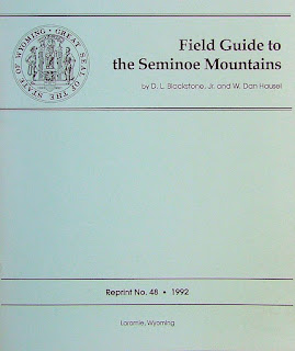
One of the first publications we released on
the Seminoe Mountains. Co-authored
with my good friend - Dr. Don Blackstone,
Jr. (RIP).
The next day, I met Charlie and Donna to look at their gold discovery near the Miracle Mile on the north flank of the Seminoe Mountains. The area of interest was dry, flat, and dusty and was part of a Tertiary to Recent unconsolidated conglomerate. They told me to dig dirt anywhere and pan for gold! Are they crazy? So, against my better judgement, I dug dirt and took it to the North Platte and panned the material - "well I'll be a monkey's uncle", I said to myself. Gold! Everywhere I sampled in this dry placer, I found gold. And with the gold - many panned samples had distinctly purple to lavender pyrope garnet - the same kind typically found associated with diamond-bearing kimberlites described by Dr. John Gurney as G10 compositions at the University of Cape Town some years ago!  So, where was all of this gold coming from - most likely Bradley Peak, but how about the diamond indicator minerals? They had a source nearby - pyrope doesn't travel very far in streams before it completely disaggregates. So, up there in the Seminoe Mountains, or in the nearby Shirley Mountains (or possibly the Ferris Mountains), there was one or more diamond deposit(s). AND THIS ONE will likely be rich, based on their geochemistry. 

At the time, my research budget was minor. I was given a big job to map and find mineral deposits in Wyoming, and a research budget to pay for gas and cans of beans, so I had be use ingenuity. Luckily, one of my associates, a consulting geologist in Colorado, and one of the top diamond researchers from the former Soviet Union. I gave him some of the garnets and he sent them to a lab in Moscow for analysis: they turned out to be diamond-stability garnets (G10). 

Because of extremism of communist regimes (think Brandon), Ed was now living in the US after being censored in the USSR (kind of reminds one of FB, Twitter, Linked-In and Brandon). One day, he had enough and applied to immigrate from the USSR - so, the communist courts placed him under house arrest for 5 years in which he had to somehow find food, etc. After the 5 years, they allowed his case to be heard, and he was thinking about looking for diamonds on a chain gang in Siberia. But, Ed had a PhD in geology (not that that mattered to the commies - remember the millions of the educated people including university professors, who were part of the government genocide statistics), and was one of the top researchers. So they gave him a break immediately pack and move to seek sanctuary in the US, or face a firing squad. He chose the former, and later co-authored a book on diamonds with me. Ed was not the only person who suffered this kind of treatment. I also had other colleagues thrown out of the USSR - one was a linguistics professor at UW, and the other a geologist who worked for me at UW. The professor was given a similar court verdict. After 5 years under house arrest, he moved to Wyoming. The geologist who worked for me, was shot at by East German guards, as he escaped over a barb wire fence to West Germany. So, this is where our country is headed right now!
The Bradley Peak Hilton - where I spent my
summer vacation mapping the Seminoe
Mountains greenstone belt.

Over the years I panned out numerous pyrope garnets from this paleoplacer. Every single pyrope our lab technician (Robert Gregory) tested with the electron microprobe at the University of Wyoming, had diamond-stability geochemistry! That had never happened before. Of all of the pyrope garnets I sampled elsewhere in the past, only a small percentage had diamond-stability geochemistry. 

This data suggests there is one heck of a diamond deposit(s) hidden out there waiting to be discovered as well as some placer diamonds waiting to be found. In order to have those kinds of garnets scattered in the paleoplacer indicates the host diamond-bearing kimberlite pipe has been partially eroded and some diamonds from that hidden pipe could also be scattered in conglomerate on the north flank (and possibly south flank) of the Seminoe Mountains.

I could never get the director to request money from the legislature  to search for the source of the gold and garnets in this region. But what the heck, directors often have better things to do - such as misusing state and federal funds, harassing geologists to death, and hiring communist Chinese and Russians (and yes, it did actually happen!  

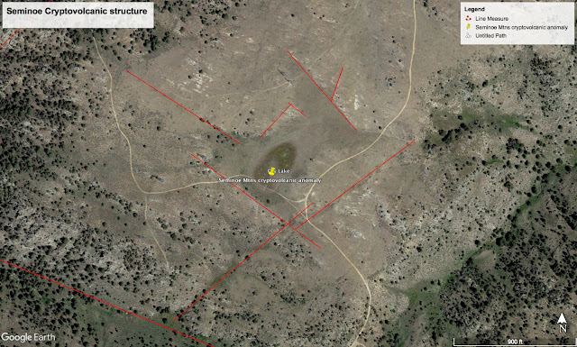
Cryptovolcanic structure found in the eastern Seminoe Mountains - does this depression sit over
a kimberlite pipe? Or is it just another intermittent pond?
So, we went searching for cryptovolcanic structures in the Seminoe Mountains and found a very good one near the eastern end of the range. Cryptovolcanic structures are geographic and geological features that have characteristics of a volcanic (in this case kimberlite) eruption, and many appear as circular depressions with vegetation anomalies that are structurally controlled. We had no budget to drill this depression, but we were able to get one of the diamond companies (the same one the operated the Kelsey Lake diamond mine in Colorado) to examine the anomaly and drill it. After drilling one hole, the went through several feet of dirt and clay and bottomed out in granite! BUT, they should have drilled  drilled a little deeper as they could easily have hit a granite xenolith similar to those found in many kimberlites, and stopped thinking it to be bed rock. 

Well, I was still not finished with my interesting experiences. When you work in the Seminoe Mountains, one should think not only about gold, but also diamonds! When I mention diamonds in this sense, I mean diamondbacks! 

I was working near Sunday Morning Creek on the North Flank of the Seminoe Mountains. It was very late in the day and time to get off the mountain. Being tired from walking all day my mind spoke to me - "watch for rattlesnakes" and just about that time, I stepped on a coiled rattlesnake! Have you ever seen a geologist in heavy hiking boots, a backpack full or rocks with a heavy utility belt break the world's  high jump and long jump record combined? Years later, I mapped the Iron Mountain kimberlite district in the Laramie Mountains, I tried to break the record again and again!

Then, I should mention komatiite. I came across komatiites a long time ago on a diamond conference in Western Australia in some gold-rich greenstone belts. Komatiites are mafic to ultramafic volcanic rocks that one erupted directly from the earth's mantle when the earth's crust was very thin (more than 2.5 Ga). I found some in the South Pass greenstone belt after Dr. Terry Klein found others in the Seminoe Mountains. These rocks are important, not only to assist us in understanding geological evolution of the earth, but since they erupted directly from the mantle of the earth, they are often good source rocks for platinum-group metals, nickel, chromium and gold.

Jasperized banded iron formation, Seminoe Mountains, WY
(Photo by Dan Hausel)


Well, I'll be a monkey's uncle! Originally, I sketched what I thought was a staff meeting.
But, I was wrong. Some years after I did this, someone pointed out not only the 2006 director of
the Wyoming Geological Survey, but there was also his buddy, the governor. So, maybe I
 accidentally sketched the Wyoming DNC and didn't realize it - hey, is that Liz and Dick?

Diamond indicator minerals from Butcherknife Draw area, southwestern Wyoming. Although
these are not from the Miracle Mile area, they are similar and include some distinct 
purple garnets (pyrope) that are derived from the diamond stability field, some reddish to brownish
almandine garnets, some orange spessartine garnets, and emerald-green chromian diopside.

Final report on the Seminoe Mountains, by W. Dan Hausel.

Like us on Facepuke, Twit and Linked-Out. Opps, never mind, our fact-checker determined these sites can't be trusted with facts or censorship. Therefore they are cancelled!

Wednesday, September 5, 2012

Seminoe Mountains Gold and Diamond Anomaly

Limonite boxworks, produced by natural rusting.
Original rocks contained pyrite (FeS2) which oxidized (rusted). 
The sulfur washed away with rain while the iron (Fe)
remained in-situ staining the rock red to brown.  Pyrite is often
gold-bearing. If the gold occurs as free gold within the pyrite
crystal structure, the pyrite will dissolve while free gold will
 remain in place. Looking in vugs  sometimes reveals visible
gold (Hausel and Hausel, 2011).
In 1981, I was working as the economic geologist for the Wyoming Geological Survey. My goal was to visit every mining district in the State and map all of the major mining districts. One of the first districts I visited was located along the edge of Bradley Peak in the Seminoe Mountains where gold had been found in the late 1800s, but mining ended due to constant battles between miners and Indians.

When I reached Bradley Peak, I found a small number of old mine dumps on the northeastern margin of Bradley Peak in an area that had been known as the Ernst Mining district, and also the Seminoe Mountains Mining district. Here I combed the mine dumps and picked several quartz specimens with limonite boxworks that contained visible gold. If one sees visible gold with the naked eye in a hand sample, a rule of thumb is that the sample will assay at least 1.0 ounce per ton in gold (opt Au) (Hausel and Hausel, 2011).

One of these had considerable visible gold (but someone else decided they liked the sample better than I did and it disappeared from my office). One of the other samples that remained in the office had no obvious visible gold but still assayed 2.87 opt Au (which means that a ton of this material would contain nearly $4900 in gold).

A gold rush followed after the Wyoming Geological Survey released information on the discovery, but unfortunately, a company known as Timberline Minerals staked all of the public land and kept all other companies out of the area (the Seminoe Mountains are surrounded by private land to the south. Along the north, there is public land and I initially accessed the area by way of Sunday Morning Creek on the north - a very rough road). Timberline was more of a promoter than exploration group and tried to sell the property. This effectively locked up the district and kept any serious exploration from occurring. Anyway, I was told that all motels were filled with geologists in Rawlins, Sinclair and Saratoga following the release of our report.

One of the Penn mines in the Seminoe Mountains as it appeared in 1981.
Since that discovery, I revisited the district and mapped the Seminoe Mountains greenstone belt and identified some interesting targets. Not only are the narrow veins of interest, but this area also encloses komatiites, metabasalts and banded iron formation that have been altered to propylitic minerals (calcite, chlorite, epidote, etc) and this altered zone contains anomalous gold. Within this zone I also picked up a sample of banded iron formation with a cross-cutting vein that assayed 1.1 opt Au. To me, this area should be an excellent gold target.

The same mine dump in the 1800s.
(American Heritage Photo,
University of Wyoming).
Note that there has been considerable
forestization during the past 100 years.
Veins on the edge of Bradley Peak have been eroding for millions of years. One drainage (Deweese Creek) is an immature drainage, but there is no evidence it had been prospected for gold or nuggets in modern times. It drains the old Penn mines at Bradley Peak and it should provide some gold (and nuggets) for some industrious prospector. The biggest problem with the drainage is the overall lack of much gravel to mine.

While mapping this area, I met two wonderful prospectors, Donna and Charlie Kortes (the Kortes Dam was named in their honor). They showed me where they had collected some quartz with visible gold at the Sunday Morning mine - I also collected a specimen of milky quartz with gem-quality chrysocolla and cuprite from the adit. Some extraordinary banded iron formation is found in this area, some would make excellent decorative stone.

Charlie and Donna took me out into the basin near the Miracle Mile along the North Platte River where they had been digging up gold in the dry alluvial gravels on both sides of the North Platte River more than a mile from the drainage. I dug gold from this alluvium at several places a mile or more from the river bank. In most of these samples, we also recovered pyrope garnets (diamond indicator mineral). EVERY pyrope we tested with the University of Wyoming's microprobe yielded diamond-stability chemistry. Such data supports there is a rich, hidden, diamond pipe(s) in the area. Although we only tested a few dozen pyropes, I've never encountered a 100% diamond stability anomaly. So when you are looking for gold in this area, keep an eye open for diamonds - there is likely diamonds in this alluvium as well as in the kimberlite pipe(s) somewhere in nearby uplifts.
References Cited

  • Hausel, W.D., 1981, Report on selected gold-bearing samples, Seminoe Mountains greenstone belt, Carbon County, Wyoming: Geological Survey 
  • Hausel, W.D., 1992, Economic geology of the Seminoe Mountains mining district, Carbon County Wyoming: Geological Survey of Wyoming Mineral Report MR92-6, 32 p.
  • , W.D., 1993, Preliminary report on the mining history, geology, geochemistry, and mineralization of the Seminoe Mountains mining district, Carbon County, Wyoming: Wyoming Geological Association Jubilee Anniversary Field Conference Guidebook, p. 387-409.
  • , W.D., 1994, Economic Geology of the Seminoe Mountains Mining District, Carbon County, Wyoming: Wyoming State Geological Survey Report of Investigations 50, 31 p.
  • , W.D., and Hausel, E.J., 2011, GOLD - Field Guide for Prospectors and Geologists (Part 1 Wyoming Examples), 366 p.


Monday, March 8, 2010

Geology & Gold in the Seminoe Mountains greenstone belt, Wyoming

In 1981, I decided to have a look at the Seminoe Mountains north of Sinclair, Wyoming. This region was basically an unknown commodity with reports of some gold in the area. Otherwise, there was little known about the precious metal in this region. After gaining access to the district, I was impressed by the geology - exposures of metamorphosed komatiites and grunerite-rich iron formation that looked like it had been squeezed by unbelievable tectonic forces.

When I reached the top of Bradley Peak at the west end of the Seminoe Mountains, I found the remains of some old gold mines. I sat down and began to examine some of the old mine dumps. Nearly every piece of milky quartz I picked up with evidence of any kind of boxworks, I found visible gold, but with a lab budget from the State of Wyoming that was laughable, I took nearly 50% of my entire annual budget and had two pieces of quartz assayed along with a a couple of pieces of banded iron formation. The assays came back with enough gold to attract the attention of every mining company in the region. Only the State Legislature didn't seem to care and I received no support from the state to speak of. Over the next month or so, every motel room in Rawlins was taken. It was like a geologists convention.

Sample of milky quartz from Penn mines, Seminoe Mountains, Wyoming. All contain visible gold. Note the circle on the one vein sample - this encloses a tiny piece of visible gold. Such a specimen, with only one tiny piece of gold will assay at least 1.0 opt Au (one ounce per ton of gold) (Hausel and Hausel, 2011).

Later, after conducting research on the mining history of the district, it became apparent that this district had been abandoned since the late 1800s.

The Seminoe Mountains were named in honor of one of General John C. Fremont's guides, Basil Cimineau Lajeunesse, a French trapper (Reed, 1872). In 1871, troops under the command of Generals Bradley of Fort Sanders and Thayer of Nebraska, set out on an expedition to the Seminoe Mountains to search for reported rich deposits of argentiferous galena (Ferry, 1871).

Instead of finding silver (which probably came from the Ferris Mountains), gold-quartz veins were discovered by Mr. Ernest, a gold prospector from Laramie who accompanied the 1871 expedition. Ernest's discovery was made along the flank of Bradley Peak (named in honor of General Bradley) about one-half mile west of Deweese Pass. Deweese Pass was named for Captain Deweese who was the first military officer to drive through the pass with wagons (Ferry, 1871).

Several gold prospects were staked following these historic expeditions. Most of the prospects were located on well-defined, gold-quartz veins along the flank of Bradley Peak and included the Ernst, Mammoth, Break of Day, Jesse Murdock, Slattery, and Edward Everett in what was initially known as the Ernst Mining district. In several instances, the ore was reported to assay as high as $100 per ton in gold (5 opt), and in one case, as high as $250 per ton (12 opt) (Morrow, 1871). In 1873, everything appeared propitious following the erection of a stamp mill by the owners of the Ernst gold mine (Reed,1873), but in the following year, all prospecting and mining came to an abrupt halt. According to an 1874 congressional report, many fatalities resulted from an Indian raid on the mining camp, and the few survivors were driven from the district (Reed, 1874). A cavalry expedition to the district reported that all 30 cabins and the stamp mill were vacated (Rawlins Sentinel, Sept. 11, 1874).

Magnesium-rich, ultramafic komatiite from the Seminoe Mountains.
 Note the unusual texture on this rock: it almost looks like fossilized
grass. This is known as spinifex texture & appears to be similar to
spinifex grasses found in Australia & Africa. These rare volcanic
rocks are found in most greenstone belts around the world and
are often associated with gold, nickel, chromium and possibly
diamonds - similar to the actinolite schists in Wawa, Canada.
The Seminoe district was avoided by the miners and prospectors for the next few years. As many as four years after the conflict, an 1878 congressional report stated... "A visit to the Seminoe Mountains found the mining camp for the most part deserted." A sample collected from the Ernst tunnel at this time assayed $106.20 in gold per ton (5.14 opt). The report went on to say, "Other prospects in this locality afford quite good indications; and, now that the Indians are no longer to be feared there, I shall expect a revival of interest in it on the return of more prosperous times " (Reed, 1878).

This optimistic report apparently did not hold true, for in an 1881 congressional report it was written that the "...shafts went down to a little depth and tunnels had been ambitiously started when this camp too was broken up by a band of hostiles..." It's not clear if this report is referring to the earlier 1874 raid or a later raid in 1881.

According to the Engineering and Mining Journal (EMJ) (1885, v. 39, April 18, p. 269), some mines in the district were purchased by the Penn Mining Company in 1885. The Penn Mining Company based out of Wilkes-Barre, Pennsylvania, was incorporated on May 5th, 1885 with a capital stock of $100,000. Five company trustees were named including Samuel Aughey, the Wyoming Territorial Geologist.

Aughey (1886) reported that the company extended the Deserted Treasure tunnel (possibly the original Ernst mine) to a length of 200 feet. The ore from the mine was described as having free milling gold in quartz associated with pyrite and chalcopyrite. The vein averaged 4 feet thick. The company constructed a 10 stamp mill with concentrator which successfully handled about 22 tons of ore per day (Warren, 1885; Aughey, 1886). Plans were made to construct another stamp mill after the Penn Mining Company struck a 6 foot gold-bearing vein (EMJ, 1886, v. 42, Oct. 9, p. 265).

A document published 10 years later in 1895 disagreed as to the success of the mill and reported the 10-stamp mill erected by the Penn Mining Company proved to be a failure due to bad management (possibly also due to the lack of oxidized ore and abundant sulfides). Three clean ups from the mill gave $8, $12, and $16 in gold per ton (EMJ, 1895, v. 59, May 18, p. 472).

Folded sample of banded iron formation from the Seminoe Mountains showing alternating layers of grunerite, magnetite and silica. The magnet sticks to the magnetite layers
Another mine operated by the Penn Mining Company, the King mine, ran almost parallel to the Deserted Treasure, but more southwesterly and northeasterly. In 1886, improvements in the King included a 120 foot drift with a 54 foot deep winze. At the bottom of the winze, the ore was 5 feet thick. Seventy tons of the King ore reduced by the mill yielded $700 in gold, but the sulfides were not saved. The East King mine shaft (an extension of the King property) and crosscut encountered a streak of very high grade, gold-bearing quartz. Other properties in the district included the Jennie, Meager, and Bennett (Aughey, 1886).

Nice sample of folded banded iron formation cobble collected in the
gold-bearing Tertiary Conglomerate paleoplacer to the north of the
Seminoe Mountains near the Miracle Mile along the Platte River.
Both gold and chrome-rich pyrope garnet are also found
 in the same area.
In addition to the lode mines, some placer activity was also reported. The EMJ (1886, v. 42, Oct. 9, p. 265) reported two placer miners (Hanley and Firth) worked a claim that yielded $0.30 to the pan. For several years after 1886, not much was reported about the Seminoe district, although Ricketts (1888) noted the occurrence of iron in the district. Then in 1894, the EMJ (1894, v. 58, Dec. 29, p. 615) reported the Penn Mining Company resumed work on its gold mines in the Seminoe Mountains after a 6 year shut down.

During this period, the mines were extended. The King mine was extended from 120 feet in 1886 to 700 feet in 1896. The vein varied from 1 to 4 feet wide with an average width of 30 inches. Assays of the vein quartz averaged $25 in gold per ton (1.2 opt) (EMJ, 1896, Aug. 8, v. 62, p. 135). The "Penn mine" tunnel was also extended to 165 feet with a 135 foot deep winze on a 3 to 5 foot wide vein. Drifts were driven along the ore body for a distance of 100 feet in each direction. The ore from the mine averaged $20 in gold per ton (1.0 opt) and carried some copper (EMJ, 1896, Aug. 8, v. 62, p. 135).

In 1902, some interest in iron was expressed when Hendricks (1902) examined the high-grade iron deposits in the Patterson Basin area along the southern flank of Bradley Peak for the Lake Superior iron company. The Patterson Basin deposits were estimated to include 1 million tons of ore averaging 60% iron.

Isoclinal, open and box folds in the Seminoe Formation banded iron
formation at Bradley Peak.
In 1906, Dickman (1906) reported some of the iron deposits in the district yielded weak precious metal anomalies. The first detailed description of the iron deposits was made by Lovering (1929). Another detailed investigation was made 37 years later by the U.S. Bureau of Mines (Harrer, 1966). Harrer estimated about 100 million tons of taconite (banded iron formation) occurred in the vicinity of Bradley Peak. In 1951, a geophysical investigation of the iron deposits of the Patterson Basin area was made Wilson Exploration Company for Empire State Oil Company of Thermopolis. Later, the U.S. Geological Survey completed an aeromagnetic survey of the district (Philbin and McCaslin, 1966). The US Bureau of Mines met its demise during the Clinton Administration due to efforts of Al Gore to eliminate this once very productive agency.

In 1979 and 1980, gold prices rose to their highest levels in history. In the following year (1981), I visited the Seminoe district and recovered of several quartz vein samples with visible gold that assayed as high as 2.87 opt (the more highly mineralized samples were not assayed). A sample of iron formation recovered at this time assayed more than 1.0 opt Au (Hausel, 1989b). Following this discovery, a gold rush occurred, and Timberline Minerals Company and Kerr McGee Corporation obtained favorable land positions.

The Seminoe Mountains greenstone in central Wyoming is a fragmented belt of Archean metamorphic rocks cropping out along the western flank of the Seminoe Mountains. The core of the Seminoe Mountains is formed by crystalline rock consisting of an ancient greenstone terrane of metamorphosed volcanic, sedimentary and plutonic rock intruded by Late Archean granodiorite. The metamorphic rocks include amphibolite, mica schist, serpentinite, ultramafic schist, metagreywacke, metapelite, and banded iron formation. The flanks of the Precambrian core are unconformably overlain by Phanerozoic sedimentary rock that form a spectacular steeply dipping precipice along the southern flank of the range.

The district is known for its iron ore and gold deposits, but also hosts some copper, silver, serpentine, asbestos, jasper, jade and leopard rock. Some previously unknown zones of anomalous lead and zinc associated with shear zones were detected during a mapping project by the author and pyrope garnets and chromian diopsides were recovered from nearby Tertiary paleoplacers. All of the kimberlitic indicator minerals tested to date have yielded diamond-stability geochemistry. These minerals are found along with detrital gold in the paleoplacer. The paleoplacer remains unexplored.

Targets of Intererst
Gossaniferous komatiite, Seminoe Mountains district.
The Bradley Peak gold deposits occur in propylitically altered metatholeiites that are altered over an area of 0.25 to 0.5 square miles. Everywhere in this altered zone, one can find gold anomalies in the quartz veins, banded iron formation and the metatholeiites themselves. This area is so underexplored that possibilities for significant gold discoveries are high. In addition, the presence of mafic and ultramafic komatiites suggest that some exploration for gold and nickel in these rocks might identify additional anomalies.

Furthermore, no one knows the extent of the Miracle Mile paleoplacer along the northern flank of the Seminoe Mountains, other than it is a large paleoplacer and one can pan gold from the concentrates along with pyrope garnets. ALL pyrope garnets tested to date have been G10-diamond stability garnets suggesting that somewhere in this region is one or more major diamondiferous kimberlite pipes!

Summary
In 1981, while conducting reconnaissance to this area the author recovered more than a dozen samples of quartz with visible gold and one assay of quartz without visible gold assayed 2.87 opt Au, and a sample of banded iron formation assayed 1.15 opt Au. This zone of mineralization occurs in a larger propylitically altered zone that likely hosts a large tonnage, low grade gold deposit with high grade quartz veins.

As incredible as it seems - this deposit remains essentially unexplored to date (2009), yet it has excellent potential for diamonds and gold!

Some Publications